Kvarken Space Conversations
Kvarken Space Conversations is a series of informative images taken from space alongside short articles. These images will be published once a month in Mega magazine on the Finnish side of the Kvarken. Longer versions of the articles can be found here in Finnish, Swedish and in English. Below, you will find links to these articles.
In addition here on the web, each image will be accompanied by informative and educating articles suitable for all ages.
General useful resources:
ESA's Newcomers Earth Observation Guide
Danish Example Cases of Copernicus Data Usage
Educational Modules - Create your own version of the images!
Below, you can find detailed recreation instructions for all of the published images! We'd be thrilled to see your versions and will publish the best ones! Please, take a look at the tutorials provided and send your versions to kvarkenspacecenter@univaasa.fi.
- Educational Module 1 to recreate "False Colors of Spring"
- Educational Module 2 to recreate "Wavelengths Tell Many Stories"
- Educational Module 3 to recreate "Springtime Vegetation Blooms"
- Recreation of "Nightlights" with the tool. Tool link and instructions of use.
Please find all the published conversations below, the latest first.
Kvarken Space Conversations #16: "InSAR and it's Applications"
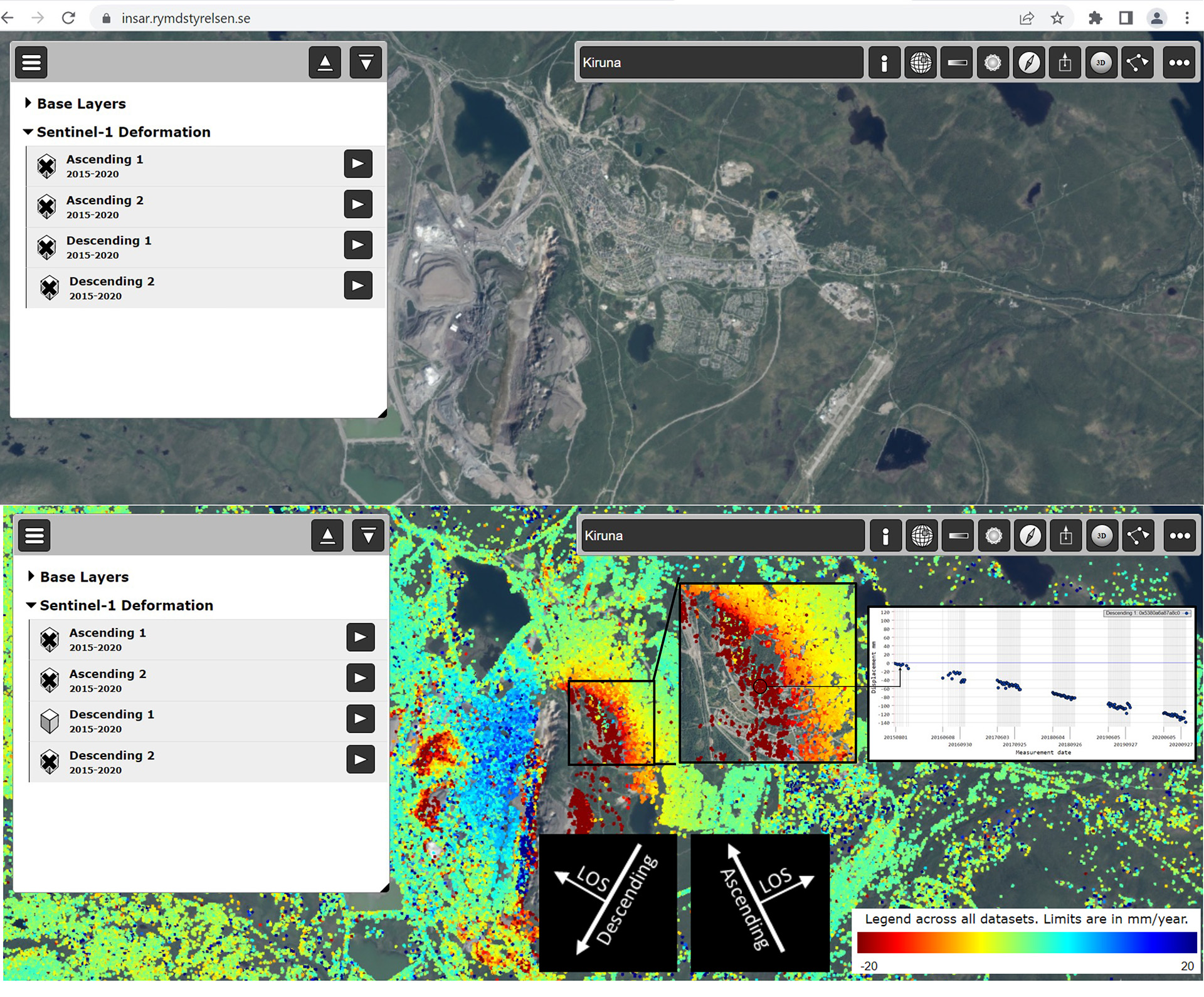
Original Conversations Article in HTML:
Kvarken Space Conversations #15: "Managing the Planet's Forests"

Extended Conversation Article
Monitoring Forest Change with Forestry Thematic Exploitation Platform (F-TEP) by VTT
Additional Information and Links in English
Below are presented a few additional resources for exploration.
Forestry Thematic Exploitation Platform
Explore the possibilities of the Forestry-TEP by yourself.
Discover this free course detailing the different aspects of the Copernicus programme, the data it provides and the techniques to work with the data provided.
Easy background reading about bark beetle infestations and how they matter in forestry.
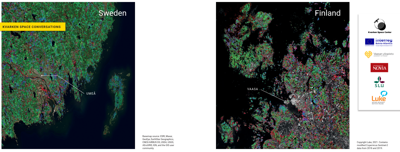
Kvarken Space Conversations #14: "Making forest maps using space data and field observations in Sweden and Finland"
Extended Conversation Article
Making forest maps using space data and field observations in Sweden and Finland
Additional Information and Links in English
Below are presented a few additional resources for exploration.
The Swedish Agricultural University has been long researching and developing forest variable estimations for Sweden. Here, additional information and the map data can be retrieved.
Finnish multi-source forest inventory data has been researched and further developed for decades now. Here, the data can be accessed.
Visualize the data yourself:
For Finland, a straightforward web-based spatial data portal. It includes the data from the latest MS-NFI. Visualize the data yourself!
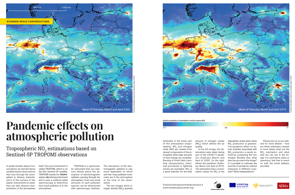
Kvarken Space Conversations #13: "Pandemic effects on Air Quality"
Extended Conversation Article
Pandemic effects on Air Quality
Additional Information and Links in English
Below are presented a few additional resources for exploration.
ESA Sentinel-5P news and latest examples
The European Space Agency's Sentinel-5P homepage. Includes fascinating examples from the latest observations.
DOAS tutorial at University of Bremen
A concise explanation of what is DOAS and how it can be utilized.
Sentinel-5P at Sentinel Online
A collection of useful links related to Sentinel-5P. Includes information about the satellite itself and details of the data products.
Hands-on trainings:
NASA Arset: High Resolution NO2 Monitoring From Space With TROPOMI
Kvarken Space Conversations #12: "The Many Colors of the Sea"
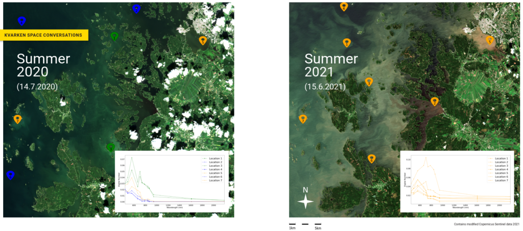 Extended Conversation Article

Physics of remote sensing of the seas and SYKE services
Additional Information and Links in English
Below are presented a few additional resources for exploration.
Copernicus Thematic Exploitation Platform: Hydrology
Contains amongst other things World Wide Harmfull Algae Blooms estimates for both sea and inland waters, including Finnish area.
Scientifically solid overview of the different aspects of optical measurements related to water bodies. Heavily recommended.
A collection of Ocean color related tools, images, data and documentation.
Hands-on trainings:
NASA Arset: Remote Sensing of coastal ecosystems
NASA Arset: Remote Sensing based Water Quality Monitoring Programs
NASA Arset: Processing Satellite Imagery for Water Quality Monitoring
NASA Arset: Remote Sensing of Harmful Algal Blooms
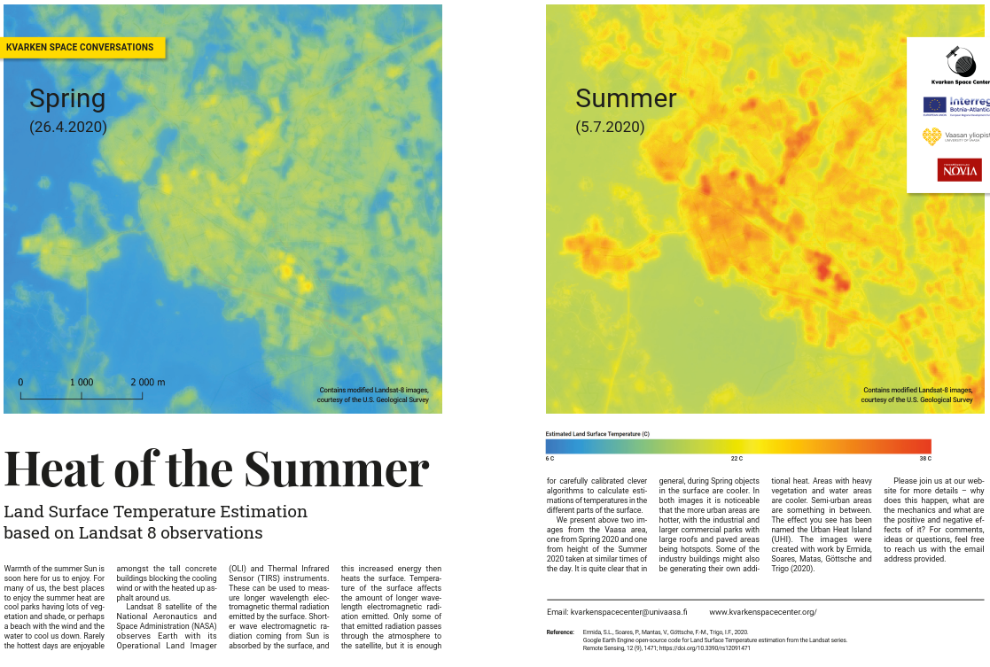
Kvarken Space Conversations #11: "Heat of the Summer"
Extended Conversation Article
Heat as electro-magnetic radiation, Land Surface Temperature observations and Urban Heat Islands
Additional Information and Links in English
Below are presented a few additional resources for exploration.
NASA Kids: What is Urban Heat Island?
Nasa's UHI information webpage is suitable for all ages and offers great summary of UHIs in easily understood compact form.
U.S. Environmental Protection Agency's Urban Heat Island Portal
Excellent, understandable portal about Urban Heat Islands, effects and mitigation filled with scientifically backed up content.
NASA Arset Training: Measuring UHIs with Satellite Remote Sensing
For a bit more advanced readers, training goes through the process of generating LST estimates with Landsat-satellites, step by step.
Kvarken Space Conversations #10: "Springtime Floods"

Extended Conversation Article
Water, local Flooding and Remote Sensing principles
Additional Information and Links in English
Below are presented a few additional resources for exploration.
USGS presenting in informative way pretty much everything you'd want to know about water cycle. Includes a section for kids!
River Flooding in Finland and in Europe
Thoroughly researched article with additional links about river flooding in Finland and in Europe.
Tutorial: Flooding Estimation using SNAP and QGIS
A very precisely guided tutorial how to test these principles in your own computer with the freely available tools.
For more advanced readers, we have collected some links to articles and tutorial training sessions on the topic of monitoring flood extent by analyzing remotely sensed data, presented below
EO4GEO / EO College: Flood mapping with synthetic aperture radar
NASA Arset Training: Satellite Remote Sensing of Flood Monitoring and Management
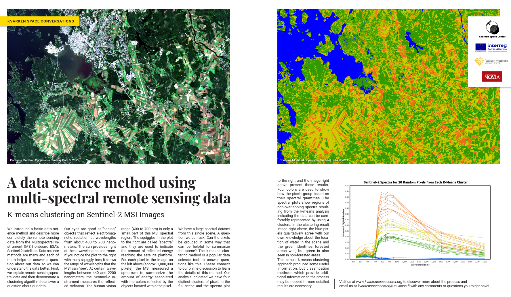
Kvarken Space Conversations #9 "A Data Science Method Using Multi-spectral Remote Sensing Data"
Extended Conversation Article
A Data Science Method Using Multi-spectral Remote Sensing Data
Additional Information and Links in English
Below are presented a few additional resources for exploration.
Article: What is Multi-spectral and Hyper-spectral?
A short article discussing differences between hyper-spectral and multi-spectral.
Article: Multi-spectral and Earth Observation
Slightly longer article discussing key elements related to multi-spectral Earth Observation, in a form of an online course.
Article: General overview of few clusterization algorithms.
A short article exploring in more detail the advantages and disadvantages of a few popular unsupervised clusterization techniques, including k-Means.
Kvarken Space Conversations #8 "Down the Ski Slopes in Northern Finland"
Extended Conversation Article
Down the Ski Slopes in Northern Finland - Interferometric calculations using Sentinel-1 observations
Additional Information and Links in English
Below are presented a few additional resources for exploration.
Online presentation of different applications of DEMs
Slideshow highlighting different DEM applications.
Video: Introduction to SAR data
Introductory video by NASA. Second part here.
First video of NASA's four part series related to SAR
For more advanced users:
Interferometric DEM creation using Sentinel-1
Excellent tutorial which you can use that as guide to follow our steps outlined in the article.
Kvarken Space Conversations #7 "Views from Inner and Outer Space"
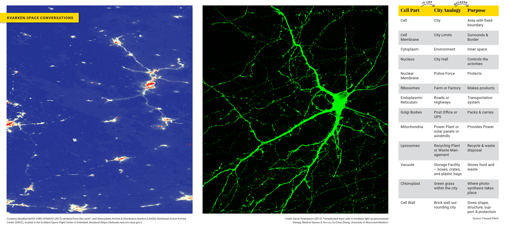
Featured Image for the Views from Inner and Outer Space
Extended Conversation Article
Cities and Cells - form and function
Additional Information and Links in English:
Below are presented few additional resources to explore the ideas of the similarities of cells and cities.
A video suitable for all ages, taking you quickly through the cell parts in cell-city analogy.
Video: Learn organelles in a cell
An educational video teaching visually functions of the basic organelles with city analogy
Other "Cell is like"-analogies
Short written piece presenting alternative analogies for cells.
Scientific take on the analogy
More scientific short discussion on the analogy and the urban form, culminating in an outdated proposed research agenda in geocomputing using cellular automata for urban systems simulation. Even though the contribution of the article is a bit outdated, the discussion is quie eye-opening.
Kvarken Space Conversations #6 "The Idea of Urban Fabrics"

Featured Image for the Idea of Urban Fabrics
(Image contains Suomen ympäristökeskus (SYKE) data & Modified Copernicus Sentinel data 2020)
Extended Conversation Articles
More discussion on urban fabrics, what it tells about the history of cities, and how it helps towards the concept of urban sustainability, below in three languages, written by us.
In English: The Idea of Urban Fabrics
Suomeksi: Kaupunkikudosten idea
På Svenska: Stadsplanering med stadsväv
Additional Information and Links in English:
Here are a few more sources to get started on understanding urban fabrics:
This site provides a basic understanding of the three different urban fabrics models.
Open Source Online course - Metabolism of cities
An open-source platform offering courses on the metabolism of cities in detail. Users can register for free and access several modules on the theme ‘Urban Metabolism’
In addition, we have additional resources collections for more advanced users:
Urban area classification using Sentinel-1 SAR coherence and backscattering
This provides an insight into the urban area classification using Sentinel-1 SAR data in SNAP and processing further in the GIS platform to understand the nature of urban zones of a city.
Sustainability and cities: extending the metabolism model
This paper discusses the simple model defined for the application of the sustainability of cities.
Kvarken Space Conversations #5 "Radar Signals are Similar to Sunlight"
 Featured Image for Radar Signals are Similar to Sunlight
(Image contains modified Copernicus Sentinel Data 2020)
Extended Conversation Articles
More discussion on radar images, its benefits, and what it offers over optical images, below in three languages, written by us.
In English: Radar Signals are Similar to Sunlight
Additional Information and Links in English:
Here are couple more layman oriented sources to get started:
Visualizing shipping lanes from Sentinel-1
Here is an excellent, easy to understand explanation on how to create a temporal summary of ship activity. Google Earth Engine script for your own testing is also provided.
Principles of Remote Sensing - Microwave Remote Sensing
This straightforward article continues along the concepts we introduced in our article going a bit further. Understandable and clearly explained.
Synthetic aperture radar (SAR) remote sensing basics and applications
This site offers interesting tutorial videos on SAR basics, radar measurement principles, data processing, and SAR applications.
In addition, we have two more resource collections for more advanced users:
NASA ARSET videos on Basics of radar imaging, processing and analysis
The videos offered by NASA ARSET will provide information on synthetic aperture radar (SAR) basics, data processing, and analysis, the information provided by different polarizations, and interferogram.
ESA advanced training course on land remote sensing
Lena Halounova discusses the radar remote sensing, synthetic aperture radar images, and its geometric properties, scattering mechanisms, statistic properties of SAR measurements, and the physical content of SAR data.
Kvarken Space Conversations #4 "Nighttime Lights"
Featured Image for Nighttime Lights
Extended Conversation Articles
For more interesting things about nighttime lights, their uses and an introduction (and a guide) to our tool that you can use globally for nighttime lights and nighttime lights change exploration below. They are written by us and available in three languages:
Additional information and links in English:
Additional interesting information about Nighttime lights and satellite instrument, VIIRS, that we used in this Conversation.
Tutorial: Turning on the Lights – An Introduction to VIIRS Nighttime Imagery
Joshua Stevens has collected compact introduction on how to use nighttime lights imagery with VIIRS instrument. To follow the instructions you will need a free NASA Earthdata account. Also it requires GDAL and some basic familiarity with the command line.
Nighttime Lights – How are they useful?
This article has a good argument on nighttime lights application for different activities. The complexity of the world makes it difficult to measure and trace activities, but satellite imagery can be seen as a tool.
Night Light Data: An Innovative Way to Track Development
Satellite images can also be used for determining socioeconomic indicators, e.g. to track development to complement accounting systems.
Earth Observatory: Observing Changes in Nighttime Lights
This article focus on the VIIRS instrument and its application. This article might interest you to understand the use of the data, which is provided by satellites.
Cities at Night: The view from Space
This article focus on urban areas and space observation, by city lights. You also find a link to NASAs video that brings us to an orbital tour around the world! Are you interested to find out more about city lights? This is just for you! Video: Cities at night: An orbital tour around the world
A bit more deeper takes on VIIRS and Google Earth Engine for the interested
Provided by NASA:
Getting Started with VIIRS Surface Reflectance Data (Part 1)
Getting Started with VIIRS Surface Reflectance Data (Part 2)
Exploring Earth’s Land Surface with Suomi NPP NASA VIIRS Land Data
Provided by Google:
This marketing video introduces Google Earth Engine tool.
Google Earth Engine Tutorials Series (11 videos)
Geo for Good 2019: Earth Engine Classification & Regression
Kvarken Space Conversations #3 "Springtime Vegetation Blooms"
Featured Image for Springtime Vegetation Blooms
(Image contains modified Copernicus Sentinel Data 2020)
Extended Conversation Articles
More discussion about indexes, the images and NDVI below, in three languages written by us.
In English: Springtime Vegetation Blooms
Additional information and links in English:
- Mobile app utilizing NDVI
- Good, short video about NDVI
- Medium.com article about indices in a bit more detail
If you want to browse NDVI index globally at your leasure, below you have few options:
- NASAs Modis instrument (16 day average)
- EO Browser
- Terrascope Viewer
For more advanced readers, a good video tutorial on how to calculate NDVI index with SNAP, please have a look here.
Kvarken Space Conversations #2 "Wavelengths Tell Many Stories"
Featured Image for "Wavelengths Tell Many Stories"
(Image contains modified Copernicus Sentinel Data 2020)
Extended Conversation Articles
More discussion about wavelengths and what they are, below in three languages, written by us.
In English: A Wavelength at the Shore
Suomeksi: Aallonpituudet rannalla
På Svenska: En våglängd vid stranden
Additional information and links in English:
- Simple interactive wave simulator
- Brief, slightly more detailed explanation of electromagnetic radiation
- VIDEO: Khan Academy: EM Waves & Spectrum
EO Browser is useful for quick and easy way to process and view Sentinel-2 multispectral images. Just click "Start Exploring" and get started. You can register later (it's free) if you want to access more advanced features such as custom scripting. Here, you can take a look at these possibilities.
For more advanced hands-on tutorial with Sentinel-2 MSI instrument, you can look here. You need only to install an open-source program called QGIS and then can follow the video's instructions.
For a great general and concise guide for people new to the Earth Observation, you should take a look at ESA's Newcomers Earth Observation Guide. It covers much more than just wavelengths, but it's easy to understand.
Kvarken Space Conversations #1 "False Colors of Spring"
Featured Image for "False Colors of Spring"
(Image contains modified Copernicus Sentinel data 2020, processed by Sentinel Hub)
Extended Conversation Articles
Accompanied article in Finnish, English and in Swedish:
Interested? Kiinnostuitko? Intresserad?
More easily understandable educational information about False Color images in three languages, written by us.
In English: False Color Images
Additional information and links in English:
- How human eye works (Short video)
- Human color vision (short, easy to understand article)
- Longer illustrated article about false color images in Satellite Images
Easiest way for beginners to explore false color satellite data is to utilize EO Browser. Just click "Start Exploring" and get started! You can later register (it's free) if you want to access the more advanced features.
If you'd like to follow a more advanced tutorial related to Sentinel-3 OLCI sensor, you can do so here. Please note, to follow this, you need to spend a bit of time getting familiar with the basic functionalities of SNAP. This is from ESA's RUS virtual environment series of tutorials, but you can just install the software on your own computer.