The Idea of Urban Fabrics
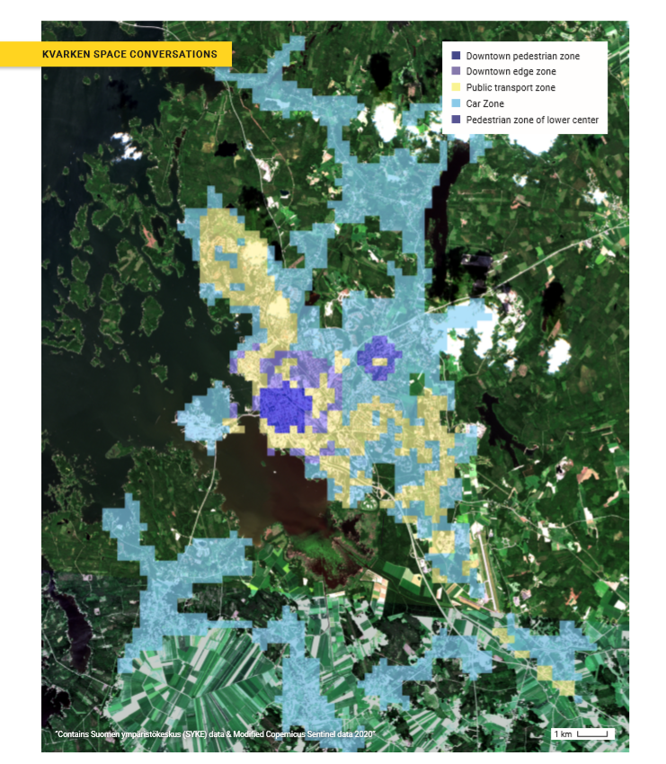
Image 1. Urban fabric summary for 2017, for the city of Vasa from SYKE overlaid on Sentinel-2 image. Click on the image to enlarge.
The colored zones displayed in the graphic above are part of an attempt to rescue humankind. How the urban areas go, so goes the world. The zones indicate the urban fabrics for the city of Vasa. The idea is that such characteristic zones for all cities in the world can tell the complex story of the history of those cities. By telling those stories, understanding of those cities’ current position relative to the concept of urban sustainability is made more clear. Importantly, knowing those current positions offers guidance to create a path for more sustainable urban futures. Finnish researchers contributed significantly to the theory of urban fabrics that are modeled in the graphic.
A terse summary of this urban fabric theory for cities is that cities will live or die, they will be enjoyable or frustrating to live in, they will have trustworthy or antisocial citizens, they will be polluting or not, they will basically work well or not work well, and they will be sustainable or not sustainable as a function of how their urban fabric summary follows certain patterns. The goal is to teach urban planners this theory so they can begin to evolve their cities to follow the desired urban fabric patterns and avoid the negative attributes mentioned here.
The urban fabric zones are labeled relative to transportation concepts: walking city fabric, transport city fabric, and car city fabric. But the characteristics of the zones are about much more than mobility. The zonal affiliations confer energy and material consumption patterns and social proximities that produce friendly neighbors or not and building geometries that reduce or increase the amount of materials for the same number of people to live. They are about mobility too.
Developed by researchers in Australia and Finland (SYKE) the concept of urban fabrics offers a much-needed way to think about and characterize cities so that when planning for future cities, more sustainable characteristics can be accomplished. Following this approach will push beneficial changes in the cities’ metabolism, their ecological footprints. When these are accomplished and more circular economies develop, the cities will be well down the path of being more sustainable. You are directed to the surprisingly readable SYKE article (Newman, Thomson, Helminen, Kosonen & Terämä (2019), SYKE 39) for a more complete description of this theory.
In our graphic above, you get SYKE’s most recent summary (2017) for the city of Vasa with interesting colors. In this spatial model summary, most problematically, Vasa’s urban fabric summary demonstrates inefficient car zones radiating tens of kilometers from the city center (a negative trait associated with excessive energy use when not overlapped by the transit zone and wasteful material use associated with construction excess from detached residential housing). The small walking zone in the city center is not effectively supported by an encircling transit zone making again car transport favored, even from short distances. This possibility is subsidized by ample underground parking which requires significant development and material consumption during construction (and will require similar expenditures in the future when demolished). Similar traits to these are common for the Finnish cities of approximately the same size as Vasa owing to their historical development patterns and limited financial opportunities for remedy.
Whilst the Vasa assessment seems harsh, on the other hand, these model assessments offer clear guidance towards a transition to a more sustainable future Vasa (all based on the urban fabrics model). Just one of the approx 10,000 cities on the planet (criteria: more than 50,000 inhabitants) needing to transition towards sustainability.
Urban fabrics theory
Cities are built from three urban fabrics (fin. kaupunkikudos) (image 2), that can overlap each other or be on their own. These are areas of the city which include a walking city fabric, a transit city fabric and a car city fabric. Each fabric has a number of specific features and properties that allow it to be identified, categorized, and defined from each other. These are used in comparison with other cities and pointing out the potential areas. (Ristimäki et al. 2017)
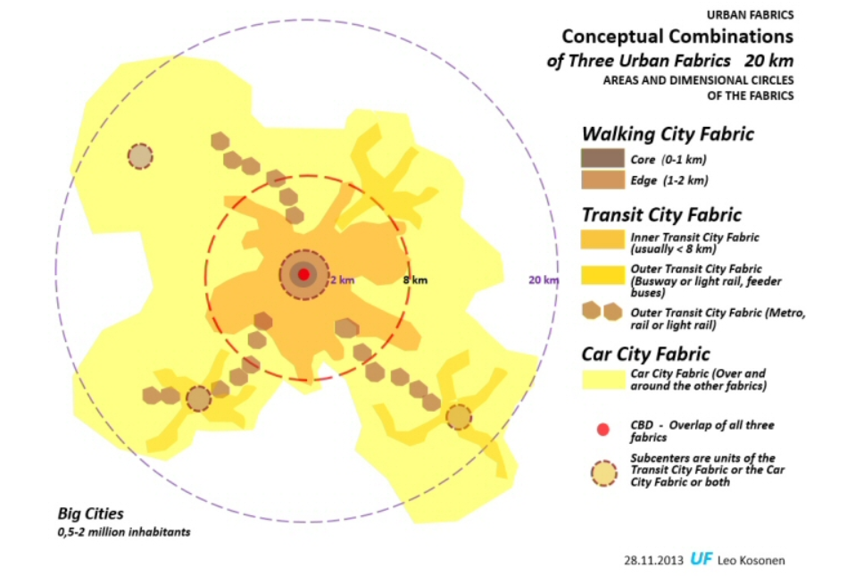
Image 2. Urban fabrics model (Leo Kosonen 2013). Click on the image to enlarge.
Walking city fabric and transit city fabric are operating with a common hierarchy based service networks and with transport networks. Car city fabric itself is a network, with its own nodes, focus point and accessibility, and has no hierarchy (like other fabrics). Hierarchy-based fabric (services and public transport) is in relation to population bases (workplaces, residences, and inhabitant concentrations) which base in distances (mode of transport and time-budget). (Ristimäki et al. 2017)
Walking city fabric is 1 kilometer from the city center (core), edge zone is 1-2 kilometers from the core. The pedestrian zone, car zone, and public transport zone are also potential for cycling (around 5 km from the core). The public transport zone (8 kilometers from the core) is not only recognition of the routes but also basic areas and local services (hospitals, health care, universities and schools, large workplace areas) that face a lot of regular passenger traffic. Those city areas that have decent public transport, decent population density (and a number of residents), and a decent amount of local services – are transit city fabrics. Car city fabric usually starts from over 5 km from the core, where the population is sparse and usage of other modes of transport needs special effort and motivation. (Ristimäki et al. 2017)